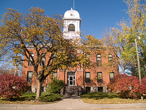
Eddy County, North Dakota
Eddy County | |
|---|---|
 | |
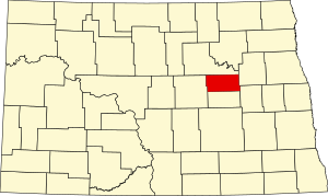
 Location within the U.S. state of North Dakota | |
 North Dakota's location within the U.S. | |
| Coordinates: 47°43′N 98°54′W / 47.72°N 98.9°W | |
| Country | |
| State | |
| Founded | 1885 |
| Seat | New Rockford |
| Largest city | New Rockford |
| Area | |
• Total | 644 sq mi (1,670 km2) |
| • Land | 630 sq mi (1,600 km2) |
| • Water | 14 sq mi (40 km2) 2.2% |
| Population (2020) | |
• Total | 2,347 |
• Estimate (2022) | 2,314 |
| • Density | 3.6/sq mi (1.4/km2) |
| Time zone | UTC−6 (Central) |
| • Summer (DST) | UTC−5 (CDT) |
| Congressional district | At-large |
| Website | Eddy County, North Dakota |
Eddy County is a county in the U.S. state of North Dakota. As of the 2020 census, the population was 2,347.[1] Its county seat is New Rockford.[2]
History
[edit]The Dakota Territory legislature created the county on March 31, 1885, with territory partitioned from Foster County. It was named for Ezra B. Eddy, a Fargo, North Dakota banker who had died a few weeks earlier. The county government was established on April 27, 1885.[3][4]
Geography
[edit]The Sheyenne River flows easterly through the upper part of the county. The county terrain consists of semi-arid hills, featuring some agriculture.[5] The terrain slopes to the east and slightly to the north, with its highest point on a hill at the county's southwestern corner, at 1,562 ft (476 m) ASL.[6] The county has a total area of 644 square miles (1,670 km2), of which 630 square miles (1,600 km2) is land and 14 square miles (36 km2) (2.2%) is water.[7] It is the smallest county in North Dakota by area.
Adjacent counties
[edit]- Benson County – north
- Nelson County – northeast
- Griggs County – southeast
- Foster County – south
- Wells County – west
Major highways
[edit]County roads
[edit]- Eddy County Road 1
- Eddy County Road 2
- Eddy County Road 3
- Eddy County Road 4
- Eddy County Road 5
- Eddy County Road 6
- Eddy County Road 7
- Eddy County Road 8
- Eddy County Road 9
- Eddy County Road 10
- Eddy County Road 12
- Eddy County Road 14
- Eddy County Road 16
Eddy County Road 14 is a north-south County Road in North Dakota. It runs from North Dakota Highway 15 near New Rockford to Eddy County Road 9 (1st Ave North) in downtown New Rockford. Eddy County Road 9 is an east-west County Road in North Dakota. It runs from US 281/Highway 15 (1st Street) in New Rockford to Wells County CR 2, near New Rockford.
National protected area
[edit]Demographics
[edit]| Census | Pop. | Note | %± |
|---|---|---|---|
| 1890 | 1,377 | — | |
| 1900 | 3,330 | 141.8% | |
| 1910 | 4,800 | 44.1% | |
| 1920 | 6,493 | 35.3% | |
| 1930 | 6,346 | −2.3% | |
| 1940 | 5,741 | −9.5% | |
| 1950 | 5,372 | −6.4% | |
| 1960 | 4,936 | −8.1% | |
| 1970 | 4,103 | −16.9% | |
| 1980 | 3,554 | −13.4% | |
| 1990 | 2,951 | −17.0% | |
| 2000 | 2,757 | −6.6% | |
| 2010 | 2,385 | −13.5% | |
| 2020 | 2,347 | −1.6% | |
| 2022 (est.) | 2,314 | [8] | −1.4% |
| U.S. Decennial Census[9] 1790-1960[10] 1900-1990[11] 1990-2000[12] 2010-2020[1] | |||
2020 census
[edit]As of the census of 2020, there were 2,347 people.
2010 census
[edit]As of the census of 2010, there were 2,385 people, 1,057 households, and 653 families in the county. The population density was 3.8 inhabitants per square mile (1.5/km2). There were 1,323 housing units at an average density of 2.1 units per square mile (0.81/km2). The racial makeup of the county was 95.2% white, 2.4% American Indian, 0.3% Asian, 0.2% black or African American, 0.1% Pacific islander, 0.8% from other races, and 1.0% from two or more races. Those of Hispanic or Latino origin made up 2.2% of the population. In terms of ancestry, 52.7% were German, 45.9% were Norwegian, 9.3% were Irish, 6.5% were Swedish, and 1.3% were American.
Of the 1,057 households, 24.2% had children under the age of 18 living with them, 50.9% were married couples living together, 7.4% had a female householder with no husband present, 38.2% were non-families, and 33.9% of all households were made up of individuals. The average household size was 2.18 and the average family size was 2.77. The median age was 49.2 years.
The median income for a household in the county was $38,404 and the median income for a family was $47,857. Males had a median income of $31,887 versus $28,194 for females. The per capita income for the county was $20,302. About 11.5% of families and 15.4% of the population were below the poverty line, including 21.0% of those under age 18 and 21.7% of those age 65 or over.
Population by decade
[edit]
Communities
[edit]Cities
[edit]- New Rockford (county seat)
- Sheyenne
Unincorporated communities
[edit]Source:[5]
- Brantford
- Hamar
Townships
[edit]- Bush
- Cherry Lake
- Columbia
- Colvin
- Eddy
- Freeborn
- Gates
- Grandfield
- Hillsdale
- Lake Washington
- Munster
- New Rockford
- Paradise
- Pleasant Prairie
- Rosefield
- Sheldon
- Superior
- Tiffany
Politics
[edit]Eddy County voters tend to vote Republican. In 71% percent of the national elections since 1960, the county selected the Republican Party candidate.
| Year | Republican | Democratic | Third party(ies) | |||
|---|---|---|---|---|---|---|
| No. | % | No. | % | No. | % | |
| 2020 | 854 | 67.72% | 383 | 30.37% | 24 | 1.90% |
| 2016 | 791 | 64.26% | 355 | 28.84% | 85 | 6.90% |
| 2012 | 634 | 54.80% | 486 | 42.01% | 37 | 3.20% |
| 2008 | 548 | 47.04% | 583 | 50.04% | 34 | 2.92% |
| 2004 | 655 | 54.00% | 534 | 44.02% | 24 | 1.98% |
| 2000 | 703 | 55.44% | 458 | 36.12% | 107 | 8.44% |
| 1996 | 517 | 40.36% | 553 | 43.17% | 211 | 16.47% |
| 1992 | 591 | 36.59% | 575 | 35.60% | 449 | 27.80% |
| 1988 | 891 | 53.74% | 748 | 45.11% | 19 | 1.15% |
| 1984 | 1,049 | 56.40% | 796 | 42.80% | 15 | 0.81% |
| 1980 | 1,153 | 61.23% | 539 | 28.62% | 191 | 10.14% |
| 1976 | 890 | 43.33% | 1,123 | 54.67% | 41 | 2.00% |
| 1972 | 1,022 | 52.04% | 911 | 46.38% | 31 | 1.58% |
| 1968 | 1,018 | 51.10% | 893 | 44.83% | 81 | 4.07% |
| 1964 | 747 | 35.78% | 1,337 | 64.03% | 4 | 0.19% |
| 1960 | 1,188 | 50.73% | 1,152 | 49.19% | 2 | 0.09% |
| 1956 | 1,239 | 56.01% | 973 | 43.99% | 0 | 0.00% |
| 1952 | 1,534 | 67.05% | 728 | 31.82% | 26 | 1.14% |
| 1948 | 952 | 46.85% | 919 | 45.23% | 161 | 7.92% |
| 1944 | 974 | 47.56% | 1,042 | 50.88% | 32 | 1.56% |
| 1940 | 1,319 | 48.42% | 1,368 | 50.22% | 37 | 1.36% |
| 1936 | 579 | 21.36% | 1,729 | 63.78% | 403 | 14.87% |
| 1932 | 537 | 21.25% | 1,888 | 74.71% | 102 | 4.04% |
| 1928 | 1,071 | 46.12% | 1,240 | 53.40% | 11 | 0.47% |
| 1924 | 881 | 39.33% | 101 | 4.51% | 1,258 | 56.16% |
| 1920 | 1,525 | 68.76% | 577 | 26.01% | 116 | 5.23% |
| 1916 | 505 | 40.21% | 650 | 51.75% | 101 | 8.04% |
| 1912 | 199 | 21.87% | 376 | 41.32% | 335 | 36.81% |
| 1908 | 540 | 58.00% | 368 | 39.53% | 23 | 2.47% |
| 1904 | 596 | 76.21% | 162 | 20.72% | 24 | 3.07% |
| 1900 | 455 | 64.45% | 235 | 33.29% | 16 | 2.27% |
See also
[edit]References
[edit]- ^ a b "State & County QuickFacts". United States Census Bureau. Retrieved April 6, 2023.
- ^ "Find a County". National Association of Counties. Archived from the original on July 4, 2012. Retrieved June 7, 2011.
- ^ "County History". Official Portal for North Dakota State Government. Archived from the original on February 2, 2015. Retrieved May 4, 2011.
- ^ "Dakota Territory, South Dakota, and North Dakota: Individual County Chronologies". Dakota Territory Atlas of Historical County Boundaries. The Newberry Library. 2006. Archived from the original on April 2, 2018. Retrieved February 3, 2015.
- ^ a b "Eddy County · North Dakota". Google Maps. Retrieved April 27, 2024.
- ^ ""Find an Altitude/Eddy County ND" Google Maps (accessed February 17, 2019)". Archived from the original on May 21, 2019. Retrieved February 18, 2019.
- ^ "2010 Census Gazetteer Files". United States Census Bureau. August 22, 2012. Archived from the original on January 29, 2015. Retrieved January 28, 2015.
- ^ "Annual Estimates of the Resident Population for Counties: April 1, 2020 to July 1, 2022". Retrieved April 6, 2023.
- ^ "U.S. Decennial Census". United States Census Bureau. Retrieved January 28, 2015.
- ^ "Historical Census Browser". University of Virginia Library. Retrieved January 28, 2015.
- ^ Forstall, Richard L., ed. (March 27, 1995). "Population of Counties by Decennial Census: 1900 to 1990". United States Census Bureau. Retrieved January 28, 2015.
- ^ "Census 2000 PHC-T-4. Ranking Tables for Counties: 1990 and 2000" (PDF). United States Census Bureau. April 2, 2001. Retrieved January 28, 2015.
- ^ Leip, David. "Atlas of US Presidential Elections". uselectionatlas.org. Retrieved April 12, 2018.


